Monday, March 26, 2012

La Paz Bolivia 20 March 2012


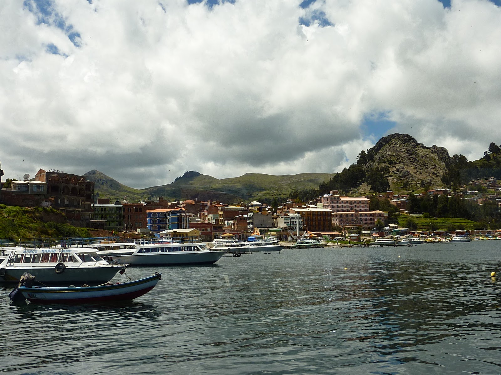
We arrived in La Paz via bus from Lake Titicaca the entry to the city is via El Alto, which is a satellite city of La Paz; it is also where the airport is situated and has an elevation of 4200 metres.
La Paz is built on very steep hills and varies in Elevation from 3000 to 4100metres, whilst in most cities the richer people live on the hills, in La Paz the opposite occurs with the poorer people living in make shift houses on the hills.
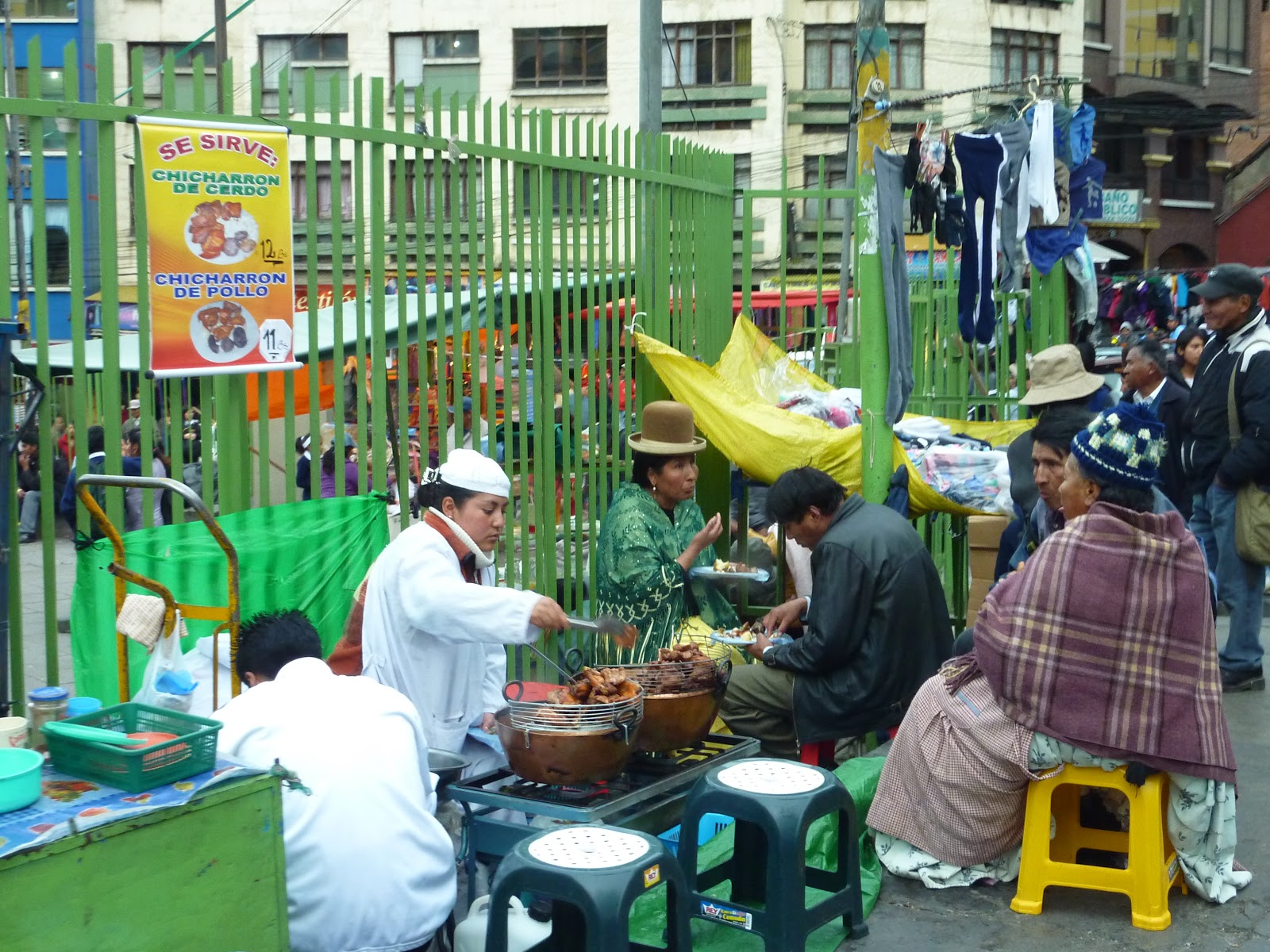
There were a lot more people here in traditional dress including women wearing the bowler hat.
We had been watching the cold temperatures in La Paz but were surprised that it was not that cold, our guide explained that the temp could vary by up to 12 degrees depending on how far down the hill you are. The official measurement is done at the airport which is at 4000 metres and thus is always much colder than the city.
The traffic is horrendous as all the roads are narrow and steep. In addition there was a demonstration on the day we were leaving with the roads to the airport blocked so we had to go to the airport 2 hours earlier than planned to allow time to get around the roadblocks.
We did manage to fit in a tour of the city and a visit to the “Witches Market”, this is where the ingredients for traditional remedies can be purchased for ceremonies held by the Aymara people – yes that is a llama foetus


We also visited a very unusual geographical formation called the “Valley of the Moon” an area where erosion has worn away the majority of the mountain leaving the effect of giant stalagmites. 
 We are on our way home now - so this is the final posting on this blog.

Tuesday, March 20, 2012

Lake Titicaca Bolivia 18 & 19 March 2012


Copacabana Bolivia

 At an altitude of 3810 metres Lake Titicaca is the highest navigable lake in the world, it is also known as the sacred lake of the Incas. It covers an area of 8300 square km and is shared between Peru & Bolivia. The lake has 72 islands the most important one being Sun Island in Bolivia
 We arrived at Sun Island after taking a bus from Puno to the border, walking across the Peru/Bolivian border and then another bus to Copacabana in Bolivia from where we boarded a catamaran that was to be our home for the night.

 The Catamaran had just 4 double twin cabins so only 8 passengers are allowed to stay on board. We felt very special when all the other people on the tour left and we were just a very small group of 7 left to enjoy the lake overnight.


The view on waking

 Sun Island is 9.6km from north to south and just 6.4km wide. The first Inca, Manco Kapac founded the Inca Empire on this island, naturally there are Inca ruins and sacred sites all over the island. Just 12 years ago the population of this island was just 70 people but this has now grown to 700 due solely to the increase in tourism.


Peru/Bolivian Border
Over 2 days we did a lot of very strenuous hiking over the island at high altitude that often left us very breathless but the views were magnificent.


.


Andean Explorer Cusco to Puno 17 March 2012


 We took the luxury train from Cusco to Puno rather than go by bus; the train was very comfortable with lounge chairs and table service.
The train left Cusco at 8am sharp and we were treated to free Pisco Sours at about 10am a bit early to start drinking but it was free.
There was some Peruvian music and dancing just before lunch at 1pm which was a 3 course meal and quite delicious.
High Tea was served at 4.30pm and we arrived in Puno at about 6pm


 We did pass through a number of towns on the way and also had a stop off at La Raya 210 km from Puno which at 4321 metres above sea level was the highest point of the trip

Views of the Andes

Doing the washing


The view from our hotel
 
Puno doesn’t have much to offer other than being a stop off for Lake Titicaca but our hotel sitting right on the edge of the lake was nice and we had Alpacas sitting outside the restaurant.

Saturday, March 17, 2012

Aguas Calientes 15 March 2012

 So after descending from Machu Pichhu we spent the night in this lovely little town full of restaurants and market stalls. The next day was raining so we decided to just wander around town and we did some souvenir shopping while waiting for the return journey.
 Aguas Calientes is around 400metres below Machu Picchu and is split in two by a river that rushes with incredible speed, it is hard to hold a conversation if you sit at the outside tables in some of the restaurants such is the noise generated by the river.


Garbage collection


This river flows through the middle of town


 The train also runs through the middle of town so that people wander across the tracks keeping an eye out for any trains that might be coming.
Peru is a beautiful country; the people are very friendly but very poor. It is incredibly cheap to eat everywhere in Peru with most meals costing less than $10 ph including a drink. We did go to what we were advised was the best restaurant in Cusco, Chi Cha run by a decorated chef from Lima, here the dearest meal on the menu was S48 with an exchange rate of S2.8 to A$1 the dearest meal worked out at A$17

Machu Picchu 14 March 2012


 The journey to Machu Picchu began at 5.45am when we were picked up and transported by car to the train station at Ollanta – a journey of about 90min through the Alps and descending into the valley a drop in altitude of over 1000metres. We then caught the Vistadome train to Aguas Calientes another 90 minutes before the harrowing 20min bus ride up the mountain to Machu Picchu. The scenery on the way was spectacular but paled against the vista of the abandoned city.

 Rediscovered by Hiram Bingham in 1911 is this Inca masterpiece. Probably built in the 15th century, immense blocks of stone fitting together with incredible precision form the walls of the city against the backdrop of Mount Huayna Picchu.
 When you see Machu Picchu nestled between the mountain tops it is hard to believe that it is actually lower than Cusco by almost 1000metres


There are a lot of theories regarding why he city was built and subsequently abandoned all within 1 century, but we will probably never know the truth.


Friday, March 16, 2012

Cusco 13 March 2012


The Cathedral

 Located at an altitude of 3,360m above sea level, Cusco was referred to as the 'Navel of the World'.Everyone tells you to take it easy when you arrive to allow the body to get used to the altitude, so we rested for a few hours. You need to be very careful when opening tubes of cream and shampoo as the contents spurt out all over the place.
Often referred to as the 'Archaeological Capital of the Americas' Cusco is a beautiful city riddled with contrasts between the indigenous styles and the modern western world. 
Plaza de Armas


The courtyard of our hotel
 The Inca walls are made from enormous granite blocks carved to fit together perfectly without the aid of mortar beds. Many of the walls were simply built upon during the construction of a new Spanish city. Its a tribute to the Incas that their anti seismic design has survived the test of time while the Spanish colonial architecture has been rebuilt several times following a wave of earthquakes that have hit the city.


Pork Shop in the town market
The city has a long and interesting history dating back to 1200AD and linked to the first Inca ruler Manco Capac. However the city saw its expansion in the 15th century under the rule of the greatest Inca Pachacutec, who led a drive that spread the boundaries of the Inca empire as far south as Chile and Argentina, and north to include Ecuador and Columbia. This rapid expansion came to an end on the invasion of the Spanish who marched into Cusco in 1534.